Triple Crown Trail Maps
Maps optimised for Garmin* watches, especially the ones with AMOLED screens (Fenix 8, Epix 2, Epix Pro, Forerunner 970...).
They work also great with other Garmin watches like the Fenix 7 6 5 series, 965, 955 and even Edge bike models and other handheld devices...
Each map is a single downloadable file that you just have to transfer to the watch using the USB cable.
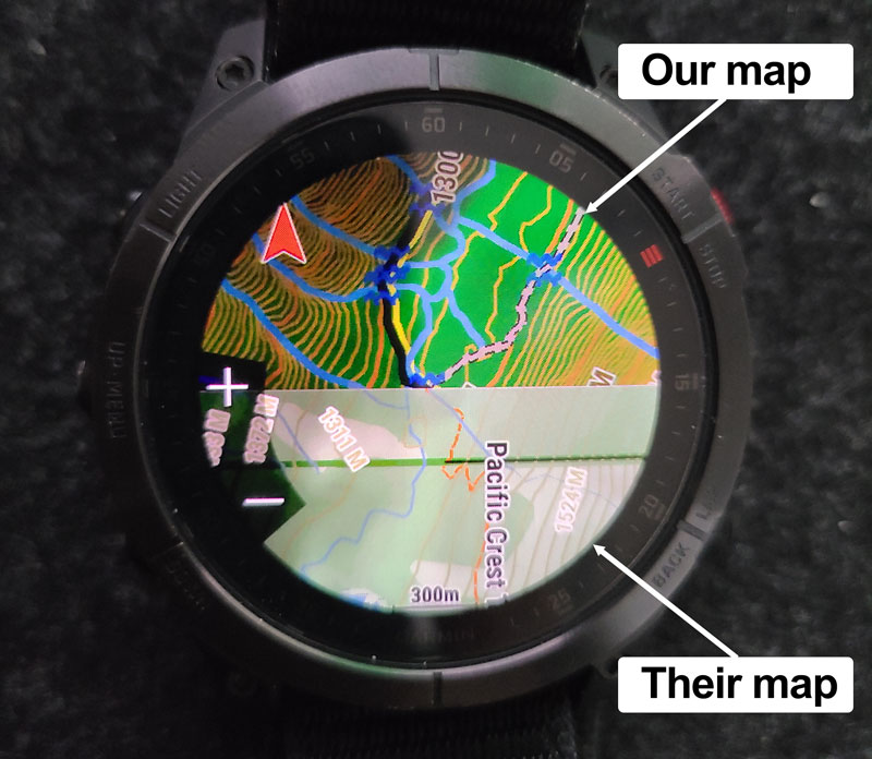
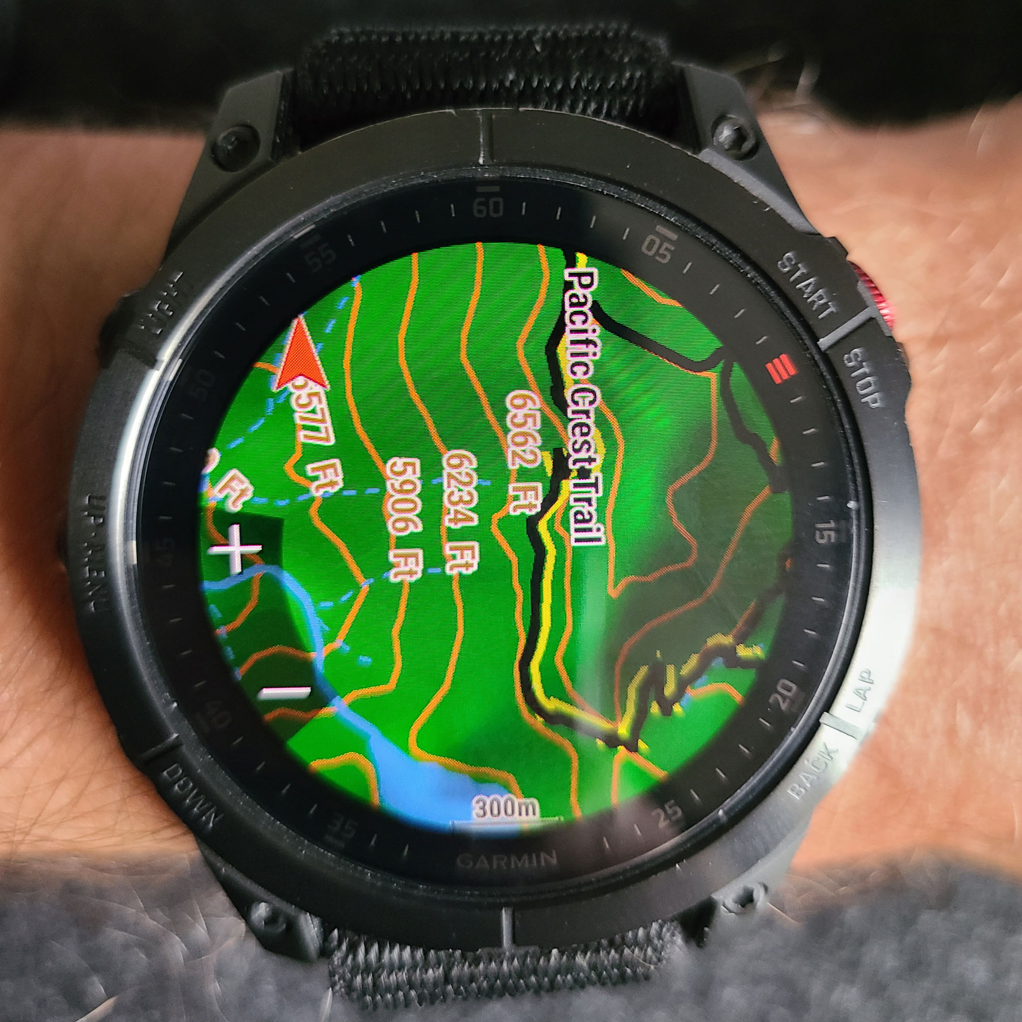
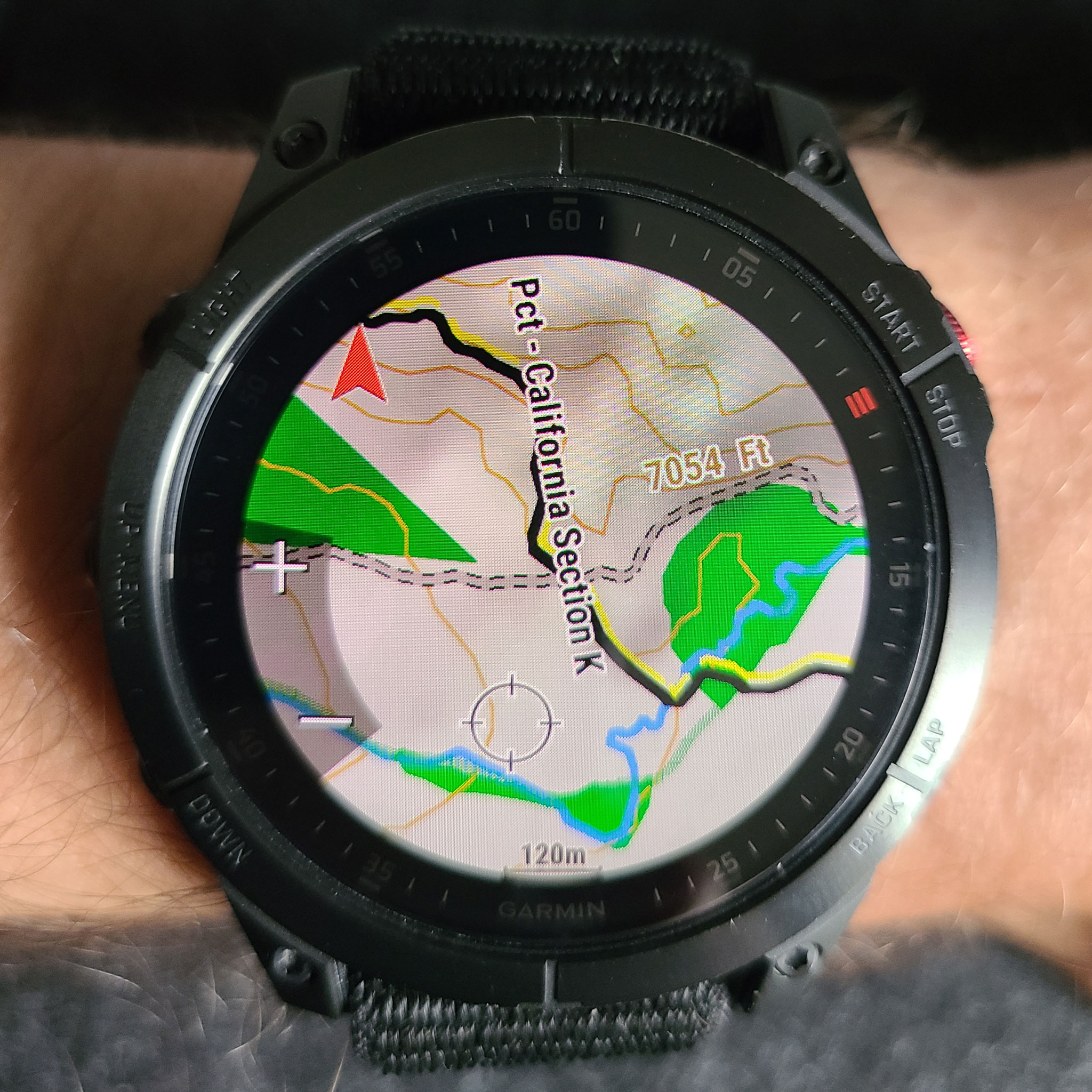
The maps are routable (you set a point on the map, and the GPS will create a route that follows hiking trails and paths to guide you to your destination), display very precise contour lines with hill shading, and have clearly readable paths.
The maps are optimized for high zoom levels and are updated every month.
Each map is a single downloadable file that you just have to transfer to the watch using the USB cable.
The maps are routable (you set a point on the map, and the GPS will create a route that follows hiking trails and paths to guide you to your destination), display very precise contour lines with hill shading, and have clearly readable paths.
The maps are optimized for high zoom levels and are updated every month.
9.99 EUR (≈USD) each.
One year free updates included.
One year free updates included.
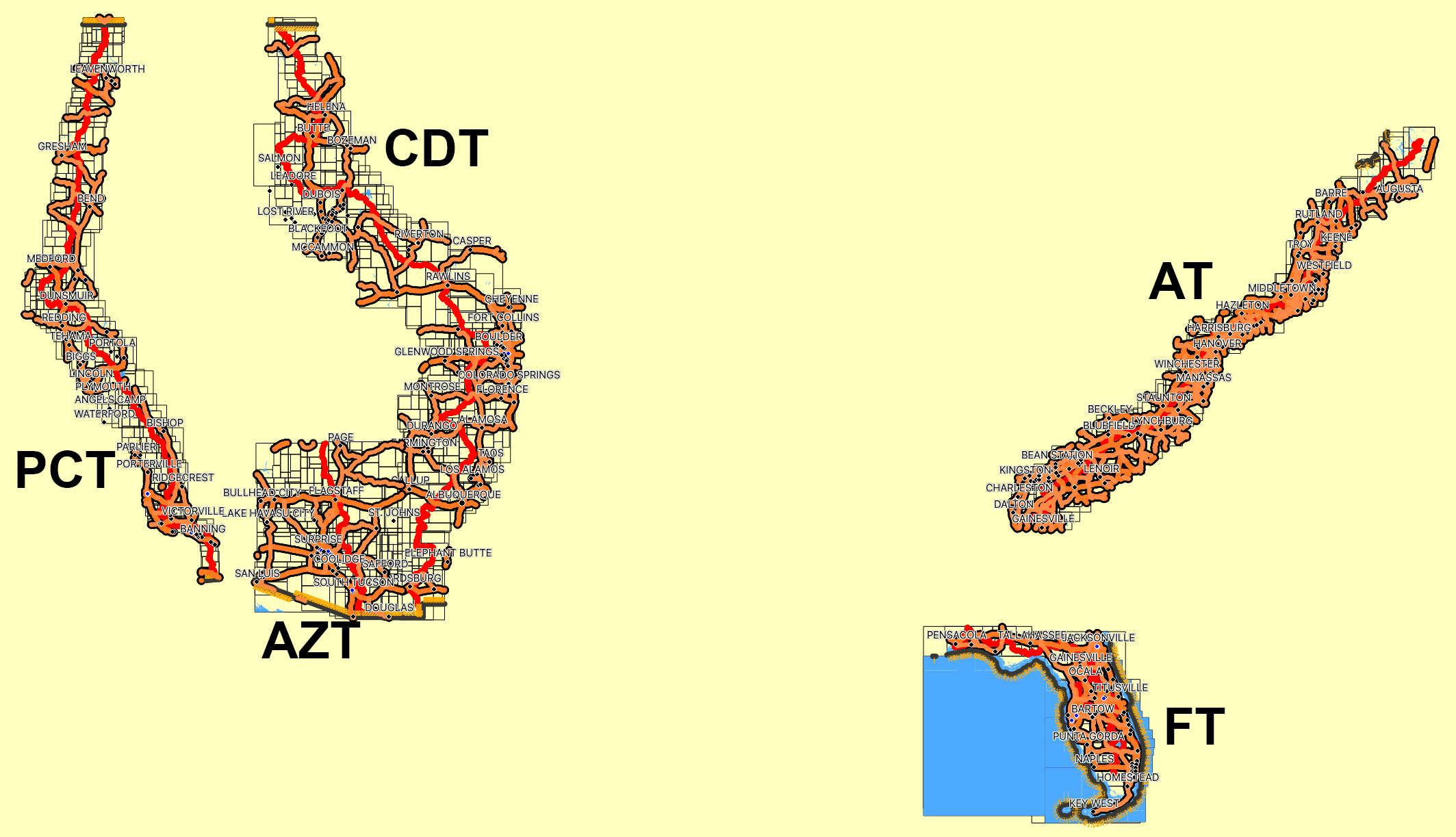
Pacific Crest Trail
Buy PCT Map Last update: May 1, 2026 01:16 PMContinental Divide Trail
Buy CDT Map Last update: May 1, 2026 01:22 PMAppalachian Trail
Buy AT Map Last update: May 1, 2026 01:19 PMFlorida Trail
Buy FT Map Last update: May 1, 2026 01:24 PMArizona Trail
Buy AZT Map Last update: May 1, 2026 01:26 PMMore pictures of the maps
Frequently Asked Questions
What is included with each map purchase?
Each map includes a single downloadable file that you can transfer to your Garmin watch. It includes detailed, routable paths, contour lines, hill-shading, and is updated monthly.
How do I download the maps?
After you make a successful PayPal payment, you will receive an email with a link to download the map. If you don't receive it, be sure to check your spam folder!
How big are the map files?
The map sizes vary between 700MB and 1GB, depending on the trail.
How do I transfer the map to my Garmin watch?
Simply connect your watch to your computer using the USB cable provided with the watch. Then transfer the map file to the GARMIN folder on your watch. Unplug your watch and it will load the map.
If you use a Mac, you need an MTP program, like OpenMTP or Android File Transfer
If you use a Mac, you need an MTP program, like OpenMTP or Android File Transfer
I transfered the map on the watch but I still see the official Garmin map
In the map parameters on the watch, check that your new map is active and the Garmin one is disabled.
Are updates included with the map purchase?
Yes, one year of updates is included with your purchase.
Which watches are supported?
All Garmin watches that come with mapping capabilities, such as the Fenix 5 6 7 8 and above series, the Epix 2, Epix Pro, the 955, 965...
Are Garmin bike computers supported?
Yes, the maps works great on all Edge devices such à the 1050, 1040, 840, 830, 540, 530... The maps are routable so you can use them to set routes from your location to wherever you want.
Can I use the maps on other Garmin GPS devices?
Yes, the maps use Garmin's standard map format, which has been in use for decades, so older units like the Etrex or Oregon handheld devices are supported.
How often are the maps updated?
Maps are updated monthly to ensure accuracy and the latest information. You can download them again for a full year after your purchase.
How can I download the updates?
Just click on the link in the confirmation email you received after the purchase and it will download the latest version of the map.
Can I give/send the maps to my friends and family?
No. You are allowed to use the maps on different devices, but only those you personnaly own.
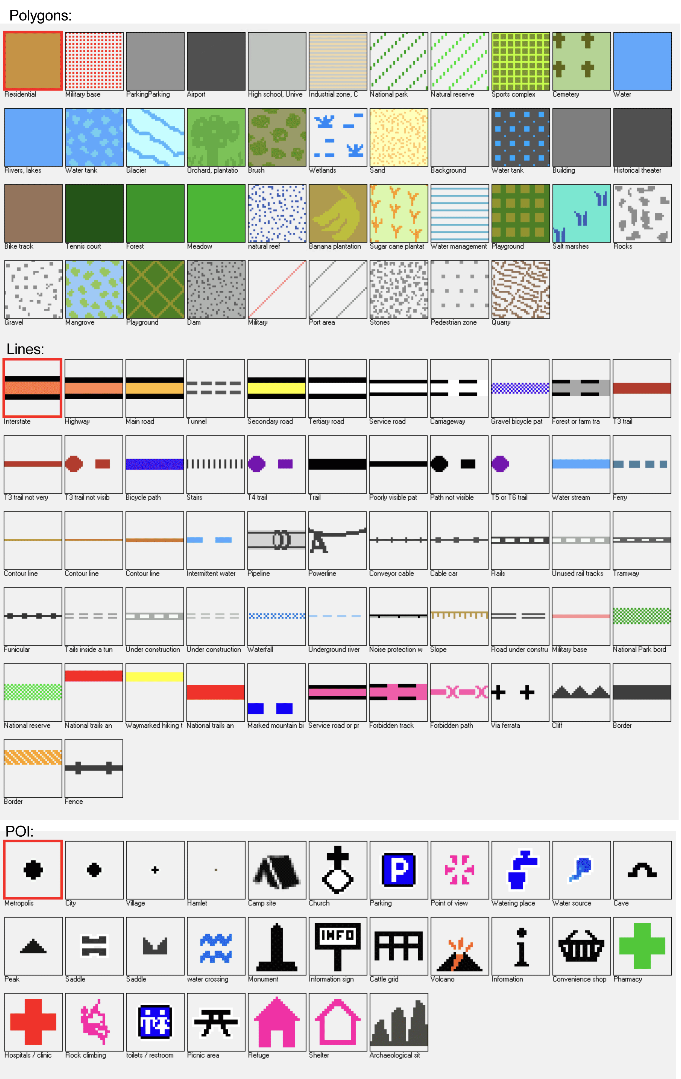
Why so few roads/trails/names at low zoom levels?
Garmin watches have a very slow processor with very little memory. Each displayed element make the map slower to navigate, we had to chose carefully what to display depending on the zoom level. If we display too much details, navigating on the map becomes very unpleasant. You can adjust the density of the displayed information with the appropriate setting ("details" in the map options settings on the watch). Garmin also adapts automatically what is shown or not to ensure that the map is not too clutered. Sometimes it is a bit annoying but we have no way to avoid that.
Can we add such or such elment on the map?
It depends. Sometimes we already tried to add some elements (for example peak names) but Garmin does not follow the instructions of the map maker 🥲. Sometimes that's an element we chose not to display to avoid to have a map that would be too cluttered with useless stuff (every shop for example). Sometimes that's just something we forgot and that would be a great idea to include a new POI (point of interest) type. So don't hesitate to contact us if you think of anything we could add to improve the map.
Is hill-shading really useful?
Hill shading makes the maps beautiful and helps to better understand the terrain, especially on AMOLED watches, but at the same time it slows down the watch, and even worse, in the field, with high zoom levels it can make the map less readable, especially if you are on a path on the south-east of a mountain (where the shadow is stronger). If you find the map too dark for your taste/watch, you can disable hill-shading in the watch parameters (on the "Map layers" section). We use a high quality hill-shading only at relatively high zoom levels to keep the maps as fast as possible. It is also disabled at the highest zooms where it makes less sense.
What is the source of the maps?
The maps are based on OpenStreetMap, with extensive customization to make them fast to display and clearly readable on the small watch screens.
Why are you selling maps based on a free source?
Generating, storing, and providing a downloadable version of these maps requires resources, which are not free. It also took a lot of my time to make these maps readable, routable, and of high quality. For example, it took days of reverse engineering and trial and error to get the contour lines positioned under the trails for better readability. Even on some official Garmin maps, this is still not well managed!
What to do if I find a bug?
It could happen, especially because OpenStreetMap maps are always evolving and Garmin is also always changing stuff that can break things in the maps. So if you find something weird that should not happen, contact us and explain what the problem is. Don't forget to specify what watch and version of the Garmin software you are using.
Contact us here:
Contact us here:
What if I have a problem or need to contact you?
Contact us :
* Triple Crown Trail Maps has no affiliation with Garmin.
Garmin® and the Garmin logo are trademarks of Garmin Ltd. or its subsidiaries, registered in the USA and other countries.